|
|
Post by anyfish247 on Feb 26, 2013 15:23:50 GMT -5
What is the best map card for SML? I have a lowrance HDS touch insight what would be the best one for this unit? Does anyone have a used one for sale?
|
|
BentRod
Global Moderator
Posts: 2,252
|
Post by BentRod on Feb 26, 2013 15:26:21 GMT -5
May HDS 8 Insight has preloaded maps on it. Is the Touch different?
|
|
|
|
Post by anyfish247 on Feb 27, 2013 20:26:13 GMT -5
It said insight map but I have not installed it on my boat yet. So I was wondering if it will show me the depths of the lake.
|
|
|
|
Post by mytoyzfishing on Feb 27, 2013 20:45:17 GMT -5
If it came preloaded with Insight than yes it will show the depth contors on the lake. At least the insight that was preloaded on my humminbird does.
|
|
|
|
Post by mwardncsu on Feb 27, 2013 20:50:13 GMT -5
The regular "Insight" has 5' or maybe 3' curves. There is an "Insight HD" card from Lowrance that had 1' curves. The Navionics top end cards have 1' curves also.
The Insight data on my Gen1 unit does not show some of the hard structure details like the road in Indian that the old LCX units did. I'd honestly have to go look at the Gen2 unit to see if it does - I think the Navionics did.
Overall the Navionics card is maybe a little better - but you'll likely find the Insight charts fine.
Now - Navionics and Lowrance are both offering products where you record sonar logs and upload them and generate your own map which you can then download - would be interesting to compare.
|
|
|
|
Post by anyfish247 on Feb 27, 2013 21:18:45 GMT -5
So yall are saying the built in map will give me the layout of the lake & depths. And what is 1 curve. Plus how can I up load a lake like Philpott if I have it saved on my computer cause it shows depth. Do I need a map card that has empty space on it or a blank SD card? Any info. would help.
|
|
|
|
Post by mwardncsu on Feb 27, 2013 21:55:33 GMT -5
1' vs 3', etc means a curve line at 1' or 3' depth increments. Have to check Lowrance or Navionics websites to confirm lake coverage. Wish I was in was on the boat now  and I'd check. The Navionics lists are definately on their website. I don't see any data show for Philpott or Claytor on the Navionics iPhone app. |
|
|
|
Post by mwardncsu on Feb 27, 2013 22:08:42 GMT -5
Here is an example of the Navionics maps from the iPhone app - 3' depth curves. 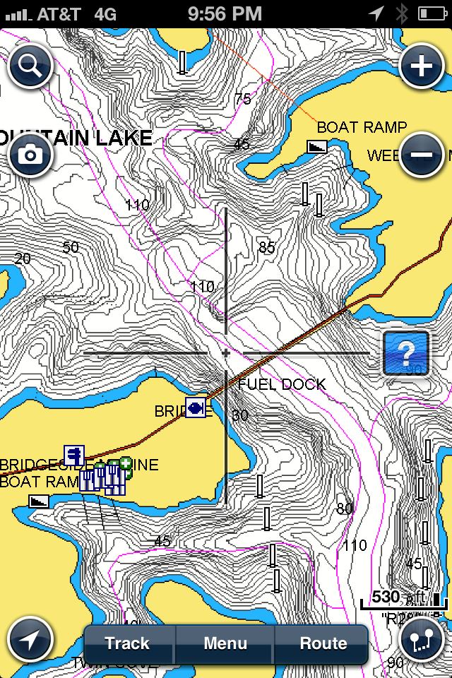 The Navionics HotMaps Premium (about $150) for a multi-state region is similar, but I believe has 1' depth curves for SML. HopMaps Platinum $199) has the 1' curves for SML for sure (but not for all lakes) and has shaded relief charts if you enable it. The one I have also covers out to the Bay (as does the Insight charts), but don't count on it for anything outside the Bay as I understand.... On the Lowrance Gen1, the HDS 5 & 7 has Lake vs. Marine Insight - the HDS 8 & 10 had both included. Not sure if this is still the same with the HDS Gen2 or Touch units or not. Confused yet? The "best" charts are probably one of th most overly complicated parts of selecting electronics and the add-ons. |
|
|
|
Post by anyfish247 on Feb 27, 2013 22:38:54 GMT -5
Been confused ever since I been playing with this hds 12 hooked to a battery in the house. I think I might have gotten in over my head. Not very educated in electronics, but I guess I will be trying now. Since I begged the wife for a bigger unit for 2 years & 2 years of saving!
|
|
|
|
Post by mwardncsu on Feb 28, 2013 7:04:42 GMT -5
I'll trade you straight-up - your 12 for a paper map from the SML Visitors Center ;D
Seriously - I misread the above and didn't realize you already had the unit in hand - use it a while and see what you think about the included Insight maps before making any decisions - the map included is likely plenty good - check out what curve detail is included (my guess is 3' curves). What part of the lake do you fish? Write down a few GPS locations and email Navionics support and tell them you are evaluating purchasing one of their cards and would like to see some examples on SML at those points or near - they will send you some screen shots and you can decide if the difference is worth the $150 or $200 more.
|
|
|
|
Post by anyfish247 on Feb 28, 2013 23:49:21 GMT -5
Is that lake map water proof & made out of gold? Just kidding! But you have been a real good help, thanks a lot!
|
|
|
|
Post by kzigmond2 on Mar 13, 2013 7:36:49 GMT -5
Hey I just got the Elite 7 HDI for my boat. Can you purchase these grids for those fishfinders as well? After reading this board I'm wishing I had spent the extra money for the HDS units but oh well. I only have the one unit so if I start fishing the way I really want. I may invest in a second one later and get a HDS then.
|
|
|
|
Post by mwardncsu on Mar 13, 2013 9:17:06 GMT -5
I believe the Elite 7 can take the Navionics cards - not the top-end one with the shaded relief, but the one just below it (still with 1' curves I believe). I'd call Lowrance support AND Navionics support both to confirm. Lowrance also offers an "Insight HD" chart card, and I know it covers SML with good topology data, but have only seen a few screen shots from around Christmas tree island on Blackwater. Ahh... here you go - all you need to know on mapping options for the Elite-7 HDI www.lowrance.com/en-US/Products/Mapping/ |
|
Brian
New Member
Posts: 611
|
Post by Brian on Dec 13, 2013 13:17:18 GMT -5
Does anyone have screenshots showing the various mapping options/levels on SML? I can find the marketing shots showing examples of other lakes, but have not found any showing exactly what you get for SML.
|
|
|
|
Post by mwardncsu on Dec 13, 2013 13:42:30 GMT -5
drop an email to Navionics and they will send you a couple of screen shots if you give them a set of coordinates - would help you decide on the various levels of product from them....
I've seen a good shot from Lowrance's higher-resolution offering - seems like it was from over at the three islands on BW side - not sure that I have a copy anymore though....
|
|


 and I'd check. The Navionics lists are definately on their website. I don't see any data show for Philpott or Claytor on the Navionics iPhone app.