|
|
Post by 2013skiff on Jul 13, 2013 18:32:44 GMT -5
where did the fish go?....went this evening didn't get on the lake till 1 pm...after 3 hours of throw netting and looking for bait I hit a school of peanuts so kept a few of them just to fish....couldn't find any fish from beaver damn to indian point so got pissed off and left...just isn't a good day when you cant catch bait...so my question is have any of you guys had any luck using peanut shad?...and why isn't any fish around the indian point area?...maybe water temps to warm?...temp was 82.7
|
|
|
|
Post by hotdog on Jul 13, 2013 18:38:48 GMT -5
I think you'll have more luck looking for them closer to the dam. Did you see any other boats catching stripers at the area you were in? They will test your patients.
|
|
BentRod
Global Moderator
Posts: 2,252
|
Post by BentRod on Jul 13, 2013 19:01:59 GMT -5
Was there a thermocline? Last time I was out there was a strong thermocline coming down the lake around the bridge area. There was light thermoclines even in the creeks on the lower end. I believe the strong thermocline was effected by all the rain water that had pushed down or out of the creeks. Weird layer from 20/25ft-40ft..this was right below Hales Ford bridge. 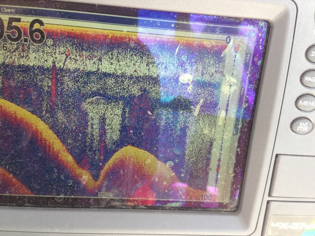 If it were me, I'd probably not waste my time above Hales Ford right now. Not to say there aren't stripers up there, but your best bet for agressive fish is probably going to be from Hales Ford to the lower end and anywhere in between. |
|
|
|
Post by 2013skiff on Jul 13, 2013 19:44:32 GMT -5
thanks for all the replies....bent rod I was wondering what that was from 20 ft to about 40 ft or so...I thought it might've been muddy water...could someone describe thermocline?...is it where not much oxygen it that section of water and why does it happen?
|
|
|
|
Post by mwardncsu on Jul 13, 2013 20:35:03 GMT -5
Yeah, two thermal breaks right now - my guess is from all the rain.... 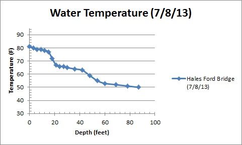 The thermocline is basically a transition in temperature of water, which causes the water to stratify - typically in the summer over time the lower layer will have the oxygen slowly consumed by decomposition and such. Just a natural part of the cycle of the lake. When the thermocline sets up, you'll typically not find Striper below it - at least not in numbers - due to depleted oxygen. They can hang at/above until the temps get too warm (above mid 60s / low 70s). |
|
|
|
Post by 2013skiff on Jul 14, 2013 10:54:07 GMT -5
thanks guys im learning more and more here....I was hitting the thermocline at beaver damn area starting at 12 feet and going to 30ft fishing in 45ft....so how does a person fish the lake this time of year?..is sections of the lake more likely to have more of a thermocline?....thans guys you are way to smart....ha ha
|
|
BentRod
Global Moderator
Posts: 2,252
|
Post by BentRod on Jul 14, 2013 11:07:16 GMT -5
The lower end doesn't get squeezed like the upper end will come July. There's plenty of oxygen and cool water down lake come August and September and a decent enough forage population..guess where the fish will be?
|
|
|
|
Post by striperjohn on Jul 14, 2013 11:15:11 GMT -5
Hey Skiff,
A buddy of mine found the following on fishingreports.com a while ago and sent it to me. Except for some of the wording this explains the thermocline pretty good. If you go to the website you can see the graphs that relate to this article.
Thermocline Fishing Tips and Diagrams..............................................................................
Posted on May 21, 2013
Finding the thermocline and how fish relate to it is very important for summer fishing. This subject is fairly dense, but I’ve included only the necessary details in this article. Make sure you check out the visuals below!
Thermocline Layer Basics
As the summer wares on, three layers of water develop on most lakes and reservoirs. The top layer, called the epilimnion, gets the most sunlight and is the warmest layer of the three. The bottom layer, called the hypolimnion, is the coldest and is least affected by the sunlight. Between these two layers lies the thermocline. All of these water conditions have specific features that attract fish for different reasons.
The top layer holds the highest amount of oxygen and, depending on wind and current, does not disperse much of that oxygen to lower layers. The hot top layer is the least dense and thus lies on top of the other two layers.
The thermocline is defined as a rapid or abrupt change in temperature relative to surrounding water. This sandwiched and relatively small layer can experiences drops of 10° within just a few feet and thus bridges the gap between the fairly consistent epilimnion and hypolimnion layers.
The bottom layer holds the least amount of oxygen and is the densest of the three layers. This layer of water has very little available oxygen because lake organisms die and sink to the bottom, and the process of decaying these dead organisms uses up all the available oxygen in the layer. In addition, the low light penetration means the lower layer does not have very much oxygen-producing aquatic life.
To sum things up, the top layer is too hot, the bottom layer has too little oxygen, and the thermocline is just right.
Fish Location Along the Thermocline
For reasons described earlier, fish don’t like it too deep or too shallow in summer. The thermocline is the best location because it offers oxygen, bait, and cool temperatures. In my experience fish generally locate on the upper side of the thermocline. If I am marking fish at 12’ the thermocline can exist anywhere between 12’ and 15’. Other cold water species like trout and pike will relate to the lower end of the thermocline due to the more preferred lower temperatures.
In the heat of summer fish will remain in the top layer too, but it is important to note that fish will rarely go below the thermocline. Basically treat the thermocline like the bottom of the lake. Never fish deeper, it is a barren wasteland void of oxygen—suitably called the ‘Dead Zone.’ Sometimes catfish and other bottom feeders will temporarily dive below the thermocline, but they can only tolerate short trips.
Locating the Thermocline
Thermoclines can be located a few different ways. The most reliable method is to dive off the boat and swim down until you sense a sudden temperature change…just kidding. Most depth finders, if you turn their sensitivity up, will present to you a fine line that represents the thermocline. Below is an example of how the thermocline usually looks on a depth finder. Note how the fish are normally found in bulk slightly above the thermocline. If you do not have a depth finder that works well, investing in a thermometer and recording the temperature at different depths is the next best way. In most lakes expect the thermocline to exist somewhere between 15 and 25 feet.
An excellent technique for fishing is to find places where the thermocline intersects with structure. Trees, humps, dips, or rock piles—if these intersect with the thermocline you’ve found yourself a gem. This takes some practice with the depth finder. Try putting around for a while in the boat to get used to how your depth finder records the thermocline and other structure.
Thermocline fishing is useful and unique because it takes work to get good at it. Most fishermen would rather not leave the shallows and will cast endlessly in the shallows—when most the fish are under the boat or behind them (and a lot less pressured too). In the dog days of summer you provide yourself a big edge to whatever other fishermen are doing by using the thermocline.
Changes in the Thermocline
Factors such as current, weather, wind, and temperature can change the thermocline depth. Some days the thermocline can be shallower than other days. Higher water visibility can make the thermocline exist deeper and vice versa. Keep in mind that thermoclines generally do not exist in lakes shallower than 15 feet and never in creeks or rivers.
|
|
|
|
Post by 2013skiff on Jul 14, 2013 13:16:48 GMT -5
great article striper john...I was thinking that the thermocline layer was the a layer for nothing to live in...so need to be looking for fish in the thermocline or above right now while water temps are high?...does the thermocline affect the bait fish any....I couldn't find any bait fish during the daylight hours...thanks
|
|
|
|
Post by striperjohn on Jul 15, 2013 6:44:30 GMT -5
The thermocline is where the bait and thus the fish should be located in hot summer weather. I know I talked to Kevin Van Dam (Pro Bass Fisherman) at the Bass Pro Shops in Hampton a couple years ago. He had just given a demo on casting etc into a big tank. He was telling a bunch of us that when he fishes tournaments on a lake like SML in the summer he looks for the thermocline first to find the bait and then structure near it where the fish will hold. Stripers are like all fish, find the food you find the fish.
|
|
|
|
Post by 2013skiff on Jul 15, 2013 9:44:39 GMT -5
I was in a thick layer of thermocline and didn't see anything in the indian point area...can anyone tell me why they run to b&bs and hang out there when they was at indian point a few weeks ago?....I don't know that much about b&bs to fish that area and don't want to jump in a crowd and get cussed at...lol....thanks guys
|
|
BentRod
Global Moderator
Posts: 2,252
|
Post by BentRod on Jul 15, 2013 12:03:37 GMT -5
Keep in mind we have a thermal refuge on the lower end of the lake with no thermocline or a very light one. This enables the stripers to have deep cool oxygenated water and forage (alewives) during the hot summer months. This is the reason most will head south. Bnbs is a typical hangout in July at times but they will move even further south if necessary. They're less likely to stay up lake in less than ideal conditions if they do not have to. Some will, but your big schools generally will not. This is nothing new..this pattern is consistent year to year.
|
|
|
|
Post by 2013skiff on Jul 15, 2013 12:21:20 GMT -5
thanks bentrod....guess I need to learn more about the lake from the bridge to the damn area....im new to the Roanoke side of the lake I grew up on blackwater side for 27 years..is there any map that would show most the creeks running into the lake?..maybe that's what I need to start with....thanks for all the help
|
|
|
|
Post by mwardncsu on Jul 15, 2013 13:01:30 GMT -5
Stop at the visitor's center at the bridge, or pick up one of the lake maps in the kisoks at one of the resturants or grocery stores around - they are pretty good and show a lot of the creek names. Some areas we talk about like "Strawberry Banks" are not so much creeks, but named for the communities near-by. This used to be a good on-line map, but seems they have changed it and it's not as helpful in terms of creek names, channel markers and such as it used to be  www.smith-mountain-lake-visitor-center.com/map_smith_mountain_lake.htm www.smith-mountain-lake-visitor-center.com/map_smith_mountain_lake.htm |
|
|
|
Post by 2013skiff on Jul 15, 2013 14:15:38 GMT -5
thanks mwardncsu...you are so smart on all this draw me a map up with all the nick names like the moormans,tennis court,jump and run,blue bird and so on...lol...thanks
|
|