|
|
Post by getlinewet on Jan 23, 2015 8:54:26 GMT -5
I wonder if someone can answer some nagging questions I have about thermoclines on SML:
1. What is the usual depths of the thermocline when it is established on the lake (if there is a "usual" depth)? Does the depth of the thermocline depend on the depth of the lake where it is positioned?
2. Approximately what time of year does the thermocline firmly establish itself on the lake?
Thanks in advance for any assistance. I know there have been threads addressing the thermocline before, but I don't recall reading answers to these specific questions.
|
|
piper
New Member
Posts: 727 
|
Post by piper on Jan 23, 2015 10:22:44 GMT -5
Usually in the 20-25 foot depth and starts setting up Mid-late June
|
|
|
|
Post by getlinewet on Jan 23, 2015 10:39:38 GMT -5
Thanks Piper
|
|
|
|
Post by striperjohn on Jan 23, 2015 10:44:10 GMT -5
I have seen very few distinctive thermoclines on sml. Mostly in coves and 50 foot or less water and during periods of no pumpback and drawdown at the dam. The depth can change from day to day. I think the fact that the water moves so much on this lake causes the temperature to fluctuate quite a bit. Thus no stable temperature levels of high o2 content. However when you do find one the bait and fish will be near it.
Sent from my SM-G900R4 using proboards
|
|
|
|
Post by getlinewet on Jan 23, 2015 10:51:40 GMT -5
Striperjohn:
Can you see it on your sonar?
|
|
|
|
Post by striperjohn on Jan 23, 2015 11:12:40 GMT -5
Yes it will appear as a dark sometimes smeary looking line that will remain at the same depth. Those few times when its thick you will see a spotty thin line at say 15 feet and from there to say 20 feet it will appear to be blotches of crap in between. Kind of like the sonar is hitting a bunch of debris at those depths. I wish I had some sonar shots to show you. Will have to scan my sd cards.
Sent from my SM-G900R4 using proboards
|
|
|
|
Post by striperjohn on Jan 23, 2015 11:30:53 GMT -5
Got this from Lowrance on google. 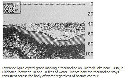 Sent from my SM-G900R4 using proboards |
|
|
|
Post by getlinewet on Jan 23, 2015 11:40:00 GMT -5
Thanks Striperjohn
|
|
piper
New Member
Posts: 727
|
Post by piper on Jan 23, 2015 17:19:37 GMT -5
Yep John, thats how I mark it. I think Ive been told what were marking is plankton or algae that hangs in that water thus the bait follow to feed? It has also been mentioned (as you said) that the water is pretty fluid in the lake between the pumping and such that it isnt very distinct. I know I mark it frequently in Craddocks where I tend to hang fwiw
|
|
|
|
Post by striperjohn on Jan 23, 2015 19:36:53 GMT -5
Actually the water in the thermocli ne is denser than the water above or below it. In the Navy the subs that took us places would hide below the thermocline because it blocked out noise that might be picked up by surface ships. The oxygen exists better in there thus denser and why bait and fish go there.
Getline if you took the pic I sent and moved it up into the water column it would be about 10 feet thick. Most that I have seen in sml are 5 ft or less.
Sent from my SM-G900R4 using proboards
|
|
Deleted
Deleted Member
Posts: 0
|
Post by Deleted on Jan 23, 2015 20:23:02 GMT -5
Actually the water in the thermocli ne is denser than the water above or below it. In the Navy the subs that took us places would hide below the thermocline because it blocked out noise that might be picked up by surface ships. The oxygen exists better in there thus denser and why bait and fish go there. Getline if you took the pic I sent and moved it up into the water column it would be about 10 feet thick. Most that I have seen in sml are 5 ft or less. Sent from my SM-G900R4 using proboards Once water temperature gets above 4C, the density drops. A thermocline is all about temperature. Thermo... Cline (temperature gradient) means the middle layer of a water column where the temperature drops more rapidly than the layers above or below. Thus, the bottom layer is rather cold and dense, and the upper layer is rather warm and not as dense. The highest density water must be at the bottom of the lake. |
|
|
|
Post by striperjohn on Jan 23, 2015 21:20:46 GMT -5
Yes the bottom should be colder and denser on a lake with no to little water movement. However sml cycles water 2 to 5 times a day(dependent upon rainfall and power requirements) which creates a circulation and mixing effect which prevents thermoclines from forming. You totally confused now getline? LOL
Sent from my SM-G900R4 using proboards
|
|
Deleted
Deleted Member
Posts: 0
|
Post by Deleted on Jan 23, 2015 22:21:22 GMT -5
I was simply arguing that the water below a thermocline is denser. That's all. You mentioned a sub strategy and said the water is less dense below the thermocline. And I'm fascinated about the submarine strategy but still don't understand what they were doing.
All I know is that a thermocline shows on sonar because the sudden density gradient caused by the sudden temperature gradient is interpreted as an actual object. As the sonar travels through the upper layer, the water density is relatively stable, then it changes dramatically followed by stable again. Yet the sonar still travels through it until it hits the bottom.
So I don't understand how the thermocline helped subs?
Or maybe.. Because the sub was directly below or even in the thermocline, it's image would get lost in the clutter? Now that makes sense to me.
By the way, the water is still denser on the bottom regardless of mixing. The mixing just interupts the thermocline that typically forms in a lake.
|
|
|
|
Post by getlinewet on Jan 24, 2015 5:28:42 GMT -5
Here's a little tidbit I took off wiki:
"Thermoclines can also be observed in lakes. In colder climates, this leads to a phenomenon called stratification. During the summer, warm water, which is less dense, will sit on top of colder, denser, deeper water with a thermocline separating them. The warm layer is called the epilimnion and the cold layer is called the hypolimnion. Because the warm water is exposed to the sun during the day, a stable system exists and very little mixing of warm water and cold water occurs, particularly in calm weather.
One result of this stability is that as the summer wears on, there is less and less oxygen below the thermocline as the water below the thermocline never circulates to the surface and organisms in the water deplete the available oxygen. As winter approaches, the temperature of the surface water will drop as nighttime cooling dominates heat transfer."
As piper and Striperjohn mentioned, SML is pretty fluid and the cycling effect probably causes the thermocline (if the season is right for thermoclines) to be sketchy at best. All I know is that thermoclines are supposed to be great areas to fish. If a thermocline exists, and if the average depth of the thermocline on SML is , say, 25', I guess that should be your target area for placing bait.
|
|
|
|
Post by striperjohn on Jan 24, 2015 8:31:04 GMT -5
Yam without providing you graphs and charts and equations--you can find all those on the internet, Subs have been doing this since the first World War. Quite simply the denser water refracts and many times blocks a sonar signal. Subs have been hiding under them for years, pretty common knowledge. We used a bathythermograph to track the temperature, particularly when we were in hostile waters. The temperature was charted at different depths thus allowing you to track the thermocline.
The 4 degrees C you mentioned, 39.2 degrees F is the point at which water becomes its most dense. If it gets colder it becomes lighter (ice floats) and this starts a lake turnover.
By the way I didn't mean to state that the O2 makes the thermocline denser, just that on our fish finders when you see a thermocline which is denser (that's why you can see it) the o2 will be there. LOL
Okay guys, sorry to bore you to death. Look it up.
|
|


